NASA Mars Reconnaissance Orbiter Spots Likely Remains Of Schiaparelli Lander | Aero-News Network
Aero-News Network
RSS icon RSS feed
podcast icon MP3 podcast
Subscribe Aero-News e-mail Newsletter Subscribe

Airborne Unlimited -- Most Recent Daily Episodes

Episode Date

Airborne-Monday

Airborne-Tuesday

Airborne-Wednesday Airborne-Thursday

Airborne-Friday

Airborne On YouTube

Airborne-Unlimited-04.01.24

Airborne-Unlimited-04.16.24

Airborne-FlightTraining-04.17.24 Airborne-Unlimited-04.11.24

Airborne-Unlimited-04.12.24

Join Us At 0900ET, Friday, 4/10, for the LIVE Morning Brief.
Watch It LIVE at
www.airborne-live.net

Tue, Oct 25, 2016

NASA Mars Reconnaissance Orbiter Spots Likely Remains Of Schiaparelli Lander

ESA Spacecraft Appears To Have Crashed On The Martian Surface

NASA's Mars Reconnaissance Orbiter has identified new markings on the surface of the Red Planet that are believed to be related to Europe's Schiaparelli test lander, which arrived at Mars on Oct. 19.

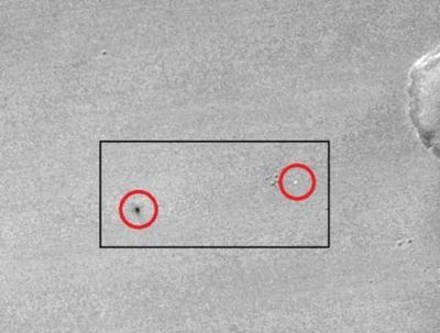
The new image shows a bright spot that may be Schiaparelli's parachute, and a larger dark spot interpreted as resulting from the impact of the lander itself following a much longer free fall than planned, after thrusters switched off prematurely. It was taken by the Context Camera (CTX) on NASA's Mars Reconnaissance Orbiter.

The location information gained from acquiring the CTX image will be used for imaging the site with the Mars Reconnaissance Orbiter's High Resolution Imaging Science Experiment (HiRISE) camera. European Space Agency (ESA) and NASA researchers will analyze the images for information about the sequence of events on Schiaparelli's landing day, possibly supplementing data transmitted from the test module during its descent.

The location of the bright spot interpreted as the parachute is 353.79 degrees east longitude, 2.07 degrees south latitude, closely matching ESA's calculation for the landing location based on landing-day data. This is within the planned landing area and about 3.3 miles (5.4 kilometers) west of the center of the landing target. A dark spot is larger and elliptical, approximately 50 by 130 feet. It may be where the lander reached the surface and exposed darker ground.

The test lander is part of ESA's ExoMars 2016 mission, which placed the Trace Gas Orbiter into orbit around Mars on Oct. 19. The orbiter will investigate Mars' atmosphere and provide relay communications capability for landers and rovers on the surface.

With CTX, HiRISE and four other instruments, the Mars Reconnaissance Orbiter has been investigating Mars since 2006.

Malin Space Science Systems, San Diego, built and operates CTX. NASA's Jet Propulsion Laboratory, a division of Caltech in Pasadena, California, manages the Mars Reconnaissance Orbiter Project for NASA's Science Mission Directorate, Washington. Lockheed Martin Space Systems, Denver, built the orbiter and collaborates with JPL to operate it.

(Image provided with NASA news release)

FMI: Full Size Image

Advertisement

More News

ANN's Daily Aero-Linx (04.15.24)

Aero Linx: International Flying Farmers IFF is a not-for-profit organization started in 1944 by farmers who were also private pilots. We have members all across the United States a>[...]

Classic Aero-TV: 'No Other Options' -- The Israeli Air Force's Danny Shapira

From 2017 (YouTube Version): Remembrances Of An Israeli Air Force Test Pilot Early in 2016, ANN contributor Maxine Scheer traveled to Israel, where she had the opportunity to sit d>[...]

Aero-News: Quote of the Day (04.15.24)

"We renegotiated what our debt restructuring is on a lot of our debts, mostly with the family. Those debts are going to be converted into equity..." Source: Excerpts from a short v>[...]

Airborne 04.16.24: RV Update, Affordable Flying Expo, Diamond Lil

Also: B-29 Superfortress Reunion, FAA Wants Controllers, Spirit Airlines Pulls Back, Gogo Galileo Van's Aircraft posted a short video recapping the goings-on around their reorganiz>[...]

ANN's Daily Aero-Term (04.16.24): Chart Supplement US

Chart Supplement US A flight information publication designed for use with appropriate IFR or VFR charts which contains data on all airports, seaplane bases, and heliports open to >[...]

blog comments powered by Disqus


Advertisement

Advertisement

Podcasts

Advertisement

© 2007 - 2024 Web Development & Design by Pauli Systems, LC