Tue, Feb 14, 2012
Integrated Flight Deck With Touchscreen Capabilities For Rotary
Wing Platforms
Garmin has taken the wraps off the G5000H at Heli-Expo 2012. The
integrated flight deck is specifically designed for twin turbine,
medium lift helicopters. The G5000H combines widescreen displays
with touchscreen controls for this class of helicopters.
“We are able to leverage our many years of experience
providing quality and reliable situational awareness capabilities
like synthetic vision, terrain alerting and datalink weather, to
design a system that specifically supports the unique needs and
challenges of the helicopter operating environment,” said
Carl Wolf, Garmin’s vice president of aviation sales and
marketing. “With HSVT and HTAWS plus innovative tools like
touchscreen control, Telligence voice command and 3D audio, the
G5000H promises to reduce workload and enhance the safety of each
mission.”
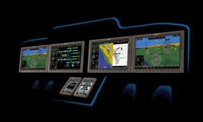
The G5000H features high-resolution, wide aspect ratio primary
flight displays (PFD) and multi-function displays (MFD). The system
supports multiple display sizes and is scalable to support a large
number of display and touchscreen controller configurations. The
landscape oriented displays have multi-pane capability that allows
multiple pages to be viewed side-by-side on any of the displays.
Therefore, pilots can simultaneously view their primary flight
display, maps, charts, checklists and system synoptics, HTAWS,
TCAS, flight planning, weather or video input pages.
The touchscreen helicopter management system gives pilots rapid
access to the flight information they want. It also has the ability
to control a variety of operations within the cockpit such as
flight management system functions, lighting, environmental
controls, electrical power distribution and hydraulic systems. It
has a menu-driven interface with intuitive icons, audio and visual
feedback, and animation so pilots know exactly how the system is
responding to their input, and the growth-oriented architecture
allows for future technologies to be accommodated via software
updates.
The G5000H also has numerous optional features:
- Helicopter Synthetic Vision Technology (HSVT) displays an
“out-the-window” view of the surroundings, regardless
of the weather conditions. HSVT seamlessly blends information about
the helicopter’s position with topographic and
helicopter-specific obstacle databases to create and display
real-time 3D images. Land, water and sky are clearly differentiated
with shading and textures that are similar to the topographical
colors found on the MFD moving map. HSVT alerts pilots of potential
ground hazards by displaying terrain and obstacles that pose a
threat to the helicopter.
- HTAWS provides graphical and audible alerts of potential
terrain and obstacle conflicts along the flight path.
Garmin’s HTAWS includes forward looking terrain avoidance
(FLTA) capability with visual and aural advisories to keep pilots
informed of hazardous terrain and obstacles.
- Worldwide datalink weather solutions enable the display of
graphical weather including NEXRAD, METARs, TAFs, TFRs, winds
aloft, echo tops, precipitation type at the surface, lightning
strikes, storm-cell data, AIRMETs, and SIGMETs.
- Traffic systems offer TAS or TCAS I capability and combine
ADS-B enhanced active and passive surveillance data to pinpoint
specific traffic threats.
- Global Connectivity Options include the ability to make and
receive phone calls, send and receive text messages and transmit
critical data off the aircraft while on the ground or in
flight.
- Advanced Audio Features including Telligence voice command, 3D
spatial audio processing, advanced auto squelch, three COM support
and backlighting and ambient noise based volume adjustment.
More News
Aero Linx: International Flying Farmers IFF is a not-for-profit organization started in 1944 by farmers who were also private pilots. We have members all across the United States a>[...]
From 2017 (YouTube Version): Remembrances Of An Israeli Air Force Test Pilot Early in 2016, ANN contributor Maxine Scheer traveled to Israel, where she had the opportunity to sit d>[...]
"We renegotiated what our debt restructuring is on a lot of our debts, mostly with the family. Those debts are going to be converted into equity..." Source: Excerpts from a short v>[...]
Also: B-29 Superfortress Reunion, FAA Wants Controllers, Spirit Airlines Pulls Back, Gogo Galileo Van's Aircraft posted a short video recapping the goings-on around their reorganiz>[...]
Chart Supplement US A flight information publication designed for use with appropriate IFR or VFR charts which contains data on all airports, seaplane bases, and heliports open to >[...]
 ANN's Daily Aero-Linx (04.15.24)

