Updated Version Of iOS App Includes Latest Navigation Features
Garmin has released an updated version of the Garmin Pilot app for the iPad and iPhone that incorporates Garmin’s dynamic navigation maps. The new dynamic maps enable numerous capabilities including track-up orientation, faster map rendering, higher resolution at tighter zoom levels and SafeTaxi integration on the moving map.
“Garmin has been providing the industry with ... dynamic mapping for over 20 years. Any pilot who has ever used a Garmin aviation portable is familiar with the inherent benefits and improved user experience that come from our dynamic maps,” said Carl Wolf, Garmin’s vice president of aviation sales and marketing. “We have drawn upon those years of experience to offer this same capability with our Garmin Pilot app, demonstrating our continued commitment to bringing industry-leading aviation features to tablets and smart phones.”
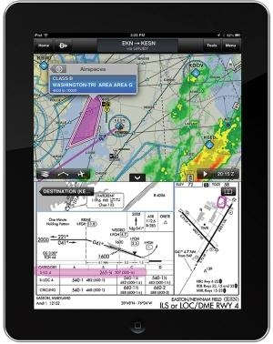
With the new dynamic maps, pilots can now choose between track-up or north-up moving map orientation. When in track-up mode, maps will dynamically adjust to the pilot’s direction of flight, ensuring the maps turn smoothly and labels are always upright and easy to read. This is in contrast to traditional static maps where labels appear in a fixed position and orientation, and when the map is rotated, labels may appear sideways or upside down. Garmin’s dynamic maps are also highly configurable, giving pilots the ability to tailor it to their personal preferences including customization of map color, visibility range and label sizes for airports, NAVAIDs and more. Pilots will now enjoy faster map rendering and the ability to zoom in tighter with consistent map resolution. And when zooming into an airport, Garmin’s exclusive SafeTaxi airport diagrams (subscription required) now automatically appear directly on the moving map without the need to switch to a dedicated airport diagram
page.
In addition to dynamic track-up on the moving map, pilots also now have the option for track-up orientation on static sectionals and en route charts, ensuring that sectionals rotate based on the pilot’s direction of flight and the aircraft is always traveling up the screen.
Enhancements to Garmin Pilot’s cloud computing technology enable seamless connectivity and information sharing between all Garmin Pilot-enabled mobile devices. Now all trips, aircraft, bookmarked flight plans, pilot details and user waypoints are automatically saved to the cloud and tied to the pilot’s username, so pilots with two devices, like a tablet and a smart phone, can log in and access their information from each one.
The ability to annotate charts is another new feature of Garmin Pilot that allows the user to highlight or make notes on approach charts and on the Airport Facilities Directory. Pilots can highlight relevant information, like minimums for example, for faster and more intuitive reference. Plus, all annotations are saved until the next chart cycle.
Every Garmin Pilot release also incorporates customer-requested features and improvements. This release includes scratch pad improvements, flight conditions color options and enhanced trip planning capabilities that are a direct result of customer comments.
The latest version of Garmin Pilot is available immediately as a free update for existing iOS Garmin Pilot subscribers. For new customers, it is available in the Apple App Store as a free download for the first 30 days. After that, pilots can pay a monthly fee of $9.99 or an annual subscription of $74.99. Pilots can optionally upgrade the standard FliteCharts to geo-referenced FliteCharts for an additional $49.99 annually. Geo-referenced SafeTaxi diagrams are available for an additional $24.99 annually. Customers using Garmin Pilot on the Android platform can expect comparable features later this year.
 Airborne 04.16.24: RV Update, Affordable Flying Expo, Diamond Lil

