Certified: Phenom 100 Synthetic Vision Technology | Aero-News Network
Aero-News Network
RSS icon RSS feed
podcast icon MP3 podcast
Subscribe Aero-News e-mail Newsletter Subscribe

Airborne Unlimited -- Most Recent Daily Episodes

Episode Date

Airborne-Monday

Airborne-Tuesday

Airborne-Wednesday Airborne-Thursday

Airborne-Friday

Airborne On YouTube

Airborne-Unlimited-04.01.24

Airborne-Unlimited-04.16.24

Airborne-FlightTraining-04.17.24 Airborne-Unlimited-04.11.24

Airborne-Unlimited-04.12.24

Join Us At 0900ET, Friday, 4/10, for the LIVE Morning Brief.
Watch It LIVE at
www.airborne-live.net

Fri, Aug 13, 2010

Certified: Phenom 100 Synthetic Vision Technology

Synth Vis Approved By FAA, EASA, ANAC For The Entry-Level Jet

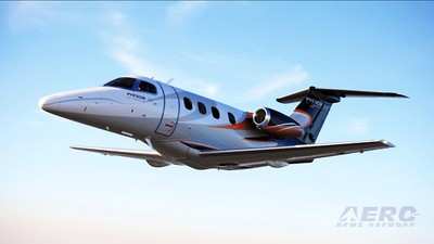
Embraer's Phenom 100 entry level executive jet has received certification from the FAA, EASA, and the Brazilian National Civil Aviation Agency (Agencia Nacional de Aviacao Civil - ANAC) to use Garmin's Synthetic Vision Technology (SVT).

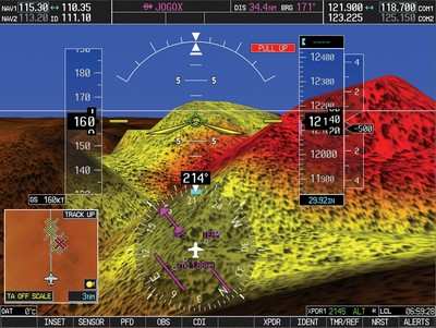
This feature recreates a visual topographic landscape from system's terrain-alerting database through a sophisticated graphics modeling, simulating what the pilot would see with the naked eye in broad daylight. It is particularly helpful in fog, rain, haze, darkness or heavy instrument flight conditions. The resulting virtual reality display offers pilots a supplemental 3-D depiction of ground, water, obstacles, airports, and traffic.

"This safety-enhancing feature allows pilots to benefit from a far easier situational orientation, reinforcing Embraer's commitment to providing a unique flight deck solution to the Phenom jets," said Mauricio Almeida, Embraer Vice President, Programs - Executive Jets.

The system counts on color-coded landscape, clearly showing with amber or red overlays those areas where potential flight-into-terrain risks exist. Towers or other obstacles that may interfere with the flight path are also color-highlighted and displayed with the appropriate symbology. SVT works with Traffic Collision Avoidance System (TCAS) and Traffic Information Service (TIS) traffic technologies to depict targets in 3-D perspective, allowing real time assessment on how close and how high they are. Using familiar TCAS symbology that grows larger as it gets nearer, SVT makes traffic conflicts easier to see and identify.


Garmin SVT File Image

Also available for retrofitting at a minimum downtime, SVT is a key feature of the Prodigy flight deck. Prodigy was exclusively developed for the Phenom jets and incorporates Embraer's extensive experience in developing cockpits for commercial and defense aircraft. Human factors, enhanced situational awareness, glass cockpit with large displays, state-of-the-art avionics and single pilot operation are the design drivers behind every detail of this flight deck.

Embraer says the certification process for SVT  for the Phenom 300 is currently under way, with entry into service expected in a few months.

FMI: www.embraer.com

Advertisement

More News

ANN's Daily Aero-Linx (04.15.24)

Aero Linx: International Flying Farmers IFF is a not-for-profit organization started in 1944 by farmers who were also private pilots. We have members all across the United States a>[...]

Classic Aero-TV: 'No Other Options' -- The Israeli Air Force's Danny Shapira

From 2017 (YouTube Version): Remembrances Of An Israeli Air Force Test Pilot Early in 2016, ANN contributor Maxine Scheer traveled to Israel, where she had the opportunity to sit d>[...]

Aero-News: Quote of the Day (04.15.24)

"We renegotiated what our debt restructuring is on a lot of our debts, mostly with the family. Those debts are going to be converted into equity..." Source: Excerpts from a short v>[...]

Airborne 04.16.24: RV Update, Affordable Flying Expo, Diamond Lil

Also: B-29 Superfortress Reunion, FAA Wants Controllers, Spirit Airlines Pulls Back, Gogo Galileo Van's Aircraft posted a short video recapping the goings-on around their reorganiz>[...]

ANN's Daily Aero-Term (04.16.24): Chart Supplement US

Chart Supplement US A flight information publication designed for use with appropriate IFR or VFR charts which contains data on all airports, seaplane bases, and heliports open to >[...]

blog comments powered by Disqus


Advertisement

Advertisement

Podcasts

Advertisement

© 2007 - 2024 Web Development & Design by Pauli Systems, LC