SR20 Flew Into "Remote Mountainous Terrain While Maneuvering"
A fully loaded airplane, high and rising terrain and a serious issue with density altitude suggest that this was a flight that needed to be conducted very carefully to be safe. And whatever the cause, there are plenty of issues to look through as yet another Cirrus SR20 (see file photo) goes down in VFR weather.

NTSB Identification: WPR12FA235
14 CFR Part 91: General Aviation
Accident occurred Tuesday, May 29, 2012 in Duck Creek Village, UT
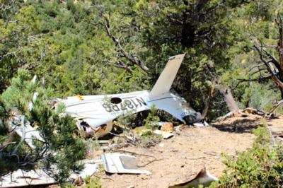
Aircraft: CIRRUS SR20, registration: N187PG
Injuries: 4 Fatal.
This is preliminary information, subject to change, and may contain errors. Any errors in this report will be corrected when the final report has been completed.
On May 29, 2012, about 1400 mountain daylight time, a Cirrus SR20 airplane, N187PG (Sherrif Dept. image below), was substantially damaged following impact with remote mountainous terrain while maneuvering near Duck Creek Village, Utah. The certified private pilot and 3 passengers sustained fatal injuries. Visual meteorological conditions prevailed for the cross-country flight, which was being operated in accordance with 14 Code of Federal Regulations Part 91, and no flight plan had been filed. The flight departed the Mesquite Airport (67L), Mesquite, Nevada, about 1155 Pacific daylight time, with Bryce Canyon Airport (BCE) as its reported destination.
According to the airport manager at 67L, the airplane landed about 1130 Pacific daylight time, refueled, and departed about 1155. Neither the pilot nor any of the three passengers indicated where the airplane had arrived from or where it would be departing to. The airport manger reported that after refueling the airplane with about 10 gallons of aviation fuel, the flight departed to the northeast, but only after performing one touch-and-go landing.
The airplane was reported overdue and missing later that afternoon. About 1930 that evening, local law enforcement personnel reported that the airplane had been located in remote mountainous terrain on the west slope of a mountain ridge about 22 nautical miles southeast of Cedar City (CDC), Utah, and about 7 nm southwest of Duck Creek Village.

On May 31, two National Transportation Safety Board investigators, accompanied by representatives from the Federal Aviation Administration, Cirrus Aircraft, and Continental Motors, Inc., traveled to the accident site. A survey of the wreckage revealed that it had come to rest inverted on a measured magnetic heading of 277 degrees, at coordinates 37 degrees 26.101 minutes north latitude and 112 degrees 45.899 minutes west longitude, and at an elevation of 7,172 feet mean sea level. There was no post crash fire. It was determined after examining the wreckage that all components necessary for flight were accounted for at the accident site.
At 1353, the weather reporting facility at CDC indicated wind variable at 4 knots with gusts to 18 knots, visibility 10 miles, sky clear, temperature 26 degrees Celsius (C), dew point -9 degrees C, and an altimeter setting of 30.09 inches of mercury.
The airplane was recovered to a secured storage facility in Phoenix, Arizona, for further examination.
 Classic Aero-TV: The Switchblade Flying Car FLIES!

