Modified Gulfstream GIII To Undertake Mapping Mission
In response to the disaster in Haiti on Jan. 12, NASA has added
a series of science overflights of earthquake faults in Haiti and
the Dominican Republic on the island of Hispaniola to a previously
scheduled three-week airborne radar campaign to Central
America.

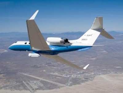
NASA's Uninhabited Aerial Vehicle Synthetic Aperture Radar, or
UAVSAR, left NASA's Dryden Flight Research Center in Edwards, CA,
on Jan. 25 aboard a modified NASA Gulfstream III aircraft.
During its trek to Central America, which will run through
mid-February, the repeat-pass L-band wavelength radar, developed by
NASA's JPL, will study the structure of tropical forests; monitor
volcanic deformation and volcano processes; and examine Mayan
archeology sites. After the Haitian earthquake, NASA managers added
additional science objectives that will allow UAVSAR's unique
observational capabilities to study geologic processes in
Hispaniola following the earthquake. UAVSAR's ability to provide
rapid access to regions of interest, short repeat flight intervals,
high resolution and its variable viewing geometry make it a
powerful tool for studying ongoing Earth processes.
"UAVSAR will allow us to image deformations of Earth's surface
and other changes associated with post-Haiti earthquake geologic
processes, such as aftershocks, earthquakes that might be triggered
by the main earthquake farther down the fault line, and the
potential for landslides," said JPL's Paul Lundgren, the principal
investigator for the Hispaniola overflights. "Because of
Hispaniola's complex tectonic setting, there is an interest in
determining if the earthquake in Haiti might trigger other
earthquakes at some unknown point in the future, either along
adjacent sections of the Enriquillo-Plantain Garden fault that was
responsible for the main earthquake, or on other faults in northern
Hispaniola, such as the Septentrional fault."
Lundgren says these upcoming flights, and others NASA will
conduct in the future, will help scientists better assess the
geophysical processes associated with earthquakes along large
faults and better understand the risks.
UAVSAR uses a technique called interferometric synthetic
aperture radar, or InSAR, that sends pulses of microwave energy
from the aircraft to the ground to detect and measure very subtle
deformations in Earth's surface, such as those caused by
earthquakes, volcanoes, landslides and glacier movements. Flying at
a nominal altitude of 12,500 meters (41,000 feet), the radar,
located in a pod under the aircraft's belly, collects data over a
selected region. It then flies over the same region again, minutes
to months later, using the aircraft's advanced navigation system to
precisely fly over the same path to an accuracy of within 5 meters
(16.5 feet). By comparing these camera-like images, interferograms
are formed that have encoded the surface deformation, from which
scientists can measure the slow surface deformations involved with
the buildup and release of strain along earthquake faults.
Since November of 2009, JPL scientists have collected data
gathered on a number of Gulfstream III flights over California's
San Andreas fault and other major California earthquake faults, a
process that will be repeated about every six months for the next
several years. From such data, scientists will create 3-D maps for
regions of interest.
Flight plans call for multiple observations of the Hispaniola
faults this week and in early to mid-February. Subsequent flights
may be added based on events in Haiti and aircraft
availability. After processing, NASA will make the UAVSAR
imagery available to the public through the JPL UAVSAR website and
the Alaska Satellite Facility Distributed Active Archive Center.
The initial data will be available in several weeks.
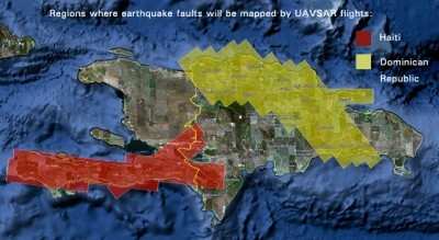
Lundgren said the Dominican Republic flights over the
Septentrional fault will provide scientists with a baseline set of
radar imagery in the event of future earthquakes there. Such
observations, combined with post-event radar imagery, will allow
scientists to measure ground deformation at the time of the
earthquakes to determine how slip on the faults is distributed and
also to monitor longer-term motions after the earthquakes to learn
more about fault zone properties. The UAVSAR data could also be
used to pinpoint exactly which part of the fault slipped during an
earthquake, data that can be used by rescue and damage assessment
officials to better estimate what areas might be most
affected.
 SpaceX to Launch Inversion RAY Reentry Vehicle in Fall

