Wed, Apr 15, 2009
Will Provide NHV Round-The-Clock Location Monitoring,
Communications
 Blue Sky Network announced this week
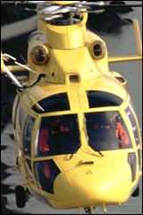
Belgian Noordzee Helikopters Vlaanderen (NHV) recently selected
Blue Sky Network’s satellite tracking and communication
solution for use aboard its work and transport helicopters, which
include Dauphin, Explorer and Calibri models.
Blue Sky Network announced this week
Belgian Noordzee Helikopters Vlaanderen (NHV) recently selected
Blue Sky Network’s satellite tracking and communication
solution for use aboard its work and transport helicopters, which
include Dauphin, Explorer and Calibri models.
The company says these new technologies will help keep the NHV's
pilots and passengers safe and in constant communication with land
and other air personnel as they work throughout the day and
night.
As NHV assists with everything from offshore hoisting and deck
landings to medical transport, Blue Sky Network's D1000A with
ACH1000 provides global satellite tracking while enabling two-way
voice and text messaging for pilots aboard the aircraft. The
convenience of the ACH1000 allows the pilot or co-pilot to take
calls directly through the headset and make calls with the ease of
speed dial.
Designed for fixed installation or complete portability, the
D1000A device tracks NHV's helicopter flight paths in near
real-time using the Iridium Satellite Network and a built-in GPS
sensor. It's also equipped with a 'Quick Position' mayday alert
button that allows pilots to notify ground personnel instantly if
an emergency arises during the flight.
"Having tracking and communication support aboard our
helicopters will surely make our jobs easier and more secure," said
Bertrand Bril, CMO of NHV. "There are no longer unknown variables,
as our helicopters are tracked and communication channels are
always open."
Working throughout Belgium and surrounding countries, NHV also
uses Blue Sky Network's unique SkyRouter to ensure its helicopters
are always on the grid. The SkyRouter Web portal provides near real
time location reporting for online monitoring of assets anywhere on
Earth. Managers are able to easily monitor and communicate with
pilots from their desks or anywhere with Internet access.
"The NHV deployment is another example of our increasing
presence around the globe," says Carlton van Putten, Vice President
of Sales and Marketing, Blue Sky Network. "We are proud to continue
our expansion with NHV by helping them manage their helicopters and
ensure they can always communicate with their aircrew, regardless
of time or location."
More News
Aero Linx: International Flying Farmers IFF is a not-for-profit organization started in 1944 by farmers who were also private pilots. We have members all across the United States a>[...]
From 2017 (YouTube Version): Remembrances Of An Israeli Air Force Test Pilot Early in 2016, ANN contributor Maxine Scheer traveled to Israel, where she had the opportunity to sit d>[...]
"We renegotiated what our debt restructuring is on a lot of our debts, mostly with the family. Those debts are going to be converted into equity..." Source: Excerpts from a short v>[...]
Also: B-29 Superfortress Reunion, FAA Wants Controllers, Spirit Airlines Pulls Back, Gogo Galileo Van's Aircraft posted a short video recapping the goings-on around their reorganiz>[...]
Chart Supplement US A flight information publication designed for use with appropriate IFR or VFR charts which contains data on all airports, seaplane bases, and heliports open to >[...]
 ANN's Daily Aero-Linx (04.15.24)

