Global Jeppesen Enroute Charts, Integration With Satcom Direct, Enhancements To Performance Flight Planning
ForeFlight, creator of the essential and widely used flight planning and electronic flight bag apps for Apple iPad, iPhone and the web, announces key enhancements to the company’s Business Performance flight planning solution.
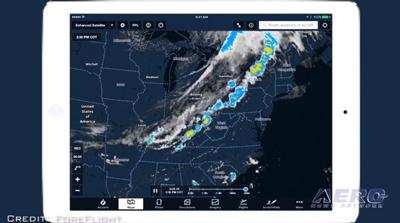
The strategic alliance between ForeFlight and Jeppesen continues to deliver more value to customers with the availability of Jeppesen’s data-driven enroute charts in ForeFlight Mobile. All customers who have purchased or linked a Jeppesen chart subscription can download the global dataset of IFR High, IFR Low, and VFR enroute charts at no additional cost or configuration required.
Jeppesen enroute charts are dynamic, responsive, full paper-replacement capable, and seamlessly integrated into the ForeFlight app. Because the charts render using data-driven technology, the type of information shown automatically adjusts based on zoom level and customers have the flexibility to customize what aeronautical data to show or hide on each map type.
Jeppesen charts combined with ForeFlight’s next-generation performance flight planning capabilities provides a compelling single-point solution for operators and pilots worldwide.
ForeFlight and Satcom Direct (SD), the business aviation connectivity provider, now offer an integrated data solution for joint Satcom Direct Router (SDR) and ForeFlight Performance customers.
Customers can now use the SDR as a GPS data source to accurately depict aircraft (ownship) position on ForeFlight’s dynamic moving map display without the need for additional GPS hardware. With GPS location, ground speed, and indicated altitude information, passengers and crew flying with their iPad or iPhone can track the flight’s progress on the map, and see real-time information like time to destination, distance to destination, and local time of arrival.
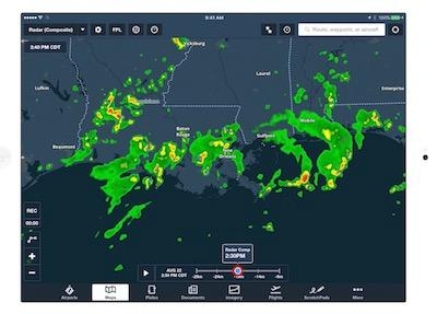
When connected to the SDR’s Wi-Fi internet, ForeFlight customers can also receive and display high-resolution radar, icing, turbulence, winds aloft, and over a dozen other graphical weather layers. With access to all the latest weather, pilots can quickly and accurately change flight plans while in the air.
The new Aircraft Manager gives flight departments a more accurate and consistent flight planning experience by allowing account administrators to create, edit, and share aircraft profiles with their team and easily publish fleet configuration changes that automatically sync to all pilot accounts. Aircraft Manager helps administrators set up their ForeFlight account faster and ensure every pilot has access to the company aircraft profiles they need for flight planning.
ForeFlight Performance helps pilots and flight departments lower costs and operate more efficiently not only through high-fidelity performance data and advanced route optimization, but also through the integration of JetFuelX contract fuel prices directly into the app. JetFuelX is ForeFlight’s web-based service that helps customers quickly determine which locations on and around their route of flight are offering the best prices based on their personal contracted rates. With JetFuelX prices displayed on the map, subscribers to ForeFlight Performance can easily compare prices from multiple fuel card memberships and pinpoint the best fuel stop location. Anyone can sign up for a free JetFuelX account at jetfuelx.com and immediately start saving on jet fuel purchases.
ForeFlight’s detailed Navlog now includes RAIM prediction to alert pilots if GPS outages are expected along the route. The alert indicates the affected portion of the flight (departure, destination, or enroute) so pilots can modify the flight plan accordingly prior to filing. RAIM service coverage currently includes flights within Continental US, Alaska, and Hawaii.
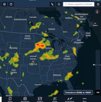
ForeFlight's industry-leading weather visualization capabilities now include new dynamic Map layers that graphically depict global icing, turbulence, and surface analysis forecasts, giving pilots and dispatchers alike the full picture of how current and forecasted weather will impact the mission. Not only for safety, but for passenger comfort, too. For example, users can quickly scrub through altitudes on the Turbulence layer to find the best ride.
ForeFlight Performance is a full end-to-end solution for pilots and flight departments who own, operate, and fly high-performance aircraft to plan, brief, and file wind-optimized routes in a matter of seconds. With features like built-in detailed performance profiles for hundreds of turbine aircraft, a sophisticated next-generation routing engine, multiple fuel policies, and easy scenario planning, ForeFlight Performance delivers faster and more accurate answers and can literally pay for itself after just one mission.
(Source: ForeFlight news release. Images from file)
 ANN's Daily Aero-Linx (04.13.24)

